Della Downhill - Lillooet, BC
The Della Creek descent is a shuttleable 1100m (3500 ft) downhill in Lillooet.
More importantly for the freeride/ downhill crowd, Della can be shuttled on a pretty good gravel road. Major hazards are wild horses and a rock slide that presents a bit of a navigation hurdle at the 1250m elevation mark.
Details inside,![photo]()
Here are some stats about Della:
- Trail length is 7.3km (all but 320m on singletrack)
- Total vertical drop is 1164m (3818 feet)
- The trail has two distinct portions both of which can be shuttled. The top portion starts in sub-alpine at 1512m (4,960 ft.). The bottom portion starts at 1270m (4,166 ft.) and descends to 348m. (1,141 ft.)
- Our average speed on these runs was 41 kmh in the lower faster portion with 25 - 30 minutes of downhill descending. You will almost always beat the shuttle driver down.
![photo]()
A lot of the forest around Lillooett burned in the long hot dry BC summer of 2009. Sadly, Della was used as a firebreak and we were told by the forest service that trees had been cut around the run and the downhill trail had been plowed and destroyed. When Kevin (our Lillooet local) went up in the spring of 2010 he found that the trail was salvageable. After a few days of work with MacLeod, shovel, chainsaw and lots of digging, Della lived!
Enjoy the fruits of our work. There are a bunch of crashes at the end:
To read more about Della, directions, more beta about the trail and the town of Lillooet see this old writeup.
![photo]()
![photo]()
![photo]()
-Lee Lau
More importantly for the freeride/ downhill crowd, Della can be shuttled on a pretty good gravel road. Major hazards are wild horses and a rock slide that presents a bit of a navigation hurdle at the 1250m elevation mark.
Details inside,
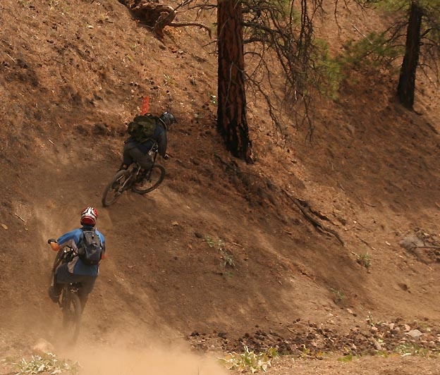
Natural half-pipe
Here are some stats about Della:
- Trail length is 7.3km (all but 320m on singletrack)
- Total vertical drop is 1164m (3818 feet)
- The trail has two distinct portions both of which can be shuttled. The top portion starts in sub-alpine at 1512m (4,960 ft.). The bottom portion starts at 1270m (4,166 ft.) and descends to 348m. (1,141 ft.)
- Our average speed on these runs was 41 kmh in the lower faster portion with 25 - 30 minutes of downhill descending. You will almost always beat the shuttle driver down.
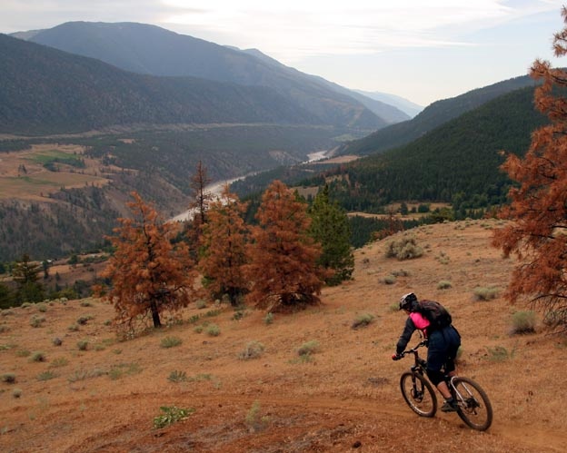
Views in the beginning of the trail
A lot of the forest around Lillooett burned in the long hot dry BC summer of 2009. Sadly, Della was used as a firebreak and we were told by the forest service that trees had been cut around the run and the downhill trail had been plowed and destroyed. When Kevin (our Lillooet local) went up in the spring of 2010 he found that the trail was salvageable. After a few days of work with MacLeod, shovel, chainsaw and lots of digging, Della lived!
Enjoy the fruits of our work. There are a bunch of crashes at the end:

To read more about Della, directions, more beta about the trail and the town of Lillooet see this old writeup.

Elevation profile - almost all downhill

Map

Google Earth profile
-Lee Lau
Author Info:

 Member since Oct 18, 2009
Must Read This Week
Sign Up for the Pinkbike Newsletter - All the Biggest, Most Interesting Stories in your Inbox
PB Newsletter Signup
We went to ride this trail, mostly (but not entirely) due to this article. My observations:
-Fun, but short (as in quick top to bottom).
-Loooong trip to get there (like, really long).
-If you are in the area, it's worthwhile, but only if you have the time to do several laps.
-Very dusty, narrow, and softer and steeper than it looks in the video.
-Scenery is spectacular (lots of wildlife. This means BEARS).
-Shuttle road was passable by my Impreza (and a lot smoother than the pick-up).
-to settle the argument, this trail is WAY more accessible from Lillooet than Lytton. We did the loop, and it took us twice as long to do the southern half as the northern. You would be lucky (or crazy) to get out of 2nd gear on the southern half of the road.
-Make sure your brakes are strong, they will get forest-fire-starting hot on the descent (before you flame me - Yes, even you speed demons).
I wouldn't make another special trip from Whistler for this trail anytime soon (it is REEEEE-mote), as the forest firebreak has mangled a fair portion of the middle of the trail, robbing the section of it's soul. The potential here is immense though, and I expect great things in the future. You may agree with me, you may not. Just throwing an opinion out there. Kudos to the gents keeping this one alive though...keep up the good work!
Finally I wish I had mentioned (my bad) that its best earlier in the spring or later in the fall when it has some rain. We hit it perfect which made trail work easy and the riding fun and fast. Right now I bet it hasn't rained there in a couple of weeks and I'm sure its dusty and loose.
We have plans for it for the fall. Hopefully restore some of the rest of the trail and build some more booters
blog.danbarham.com/2008/06/turned-out-nice-again
Gringo.
Gringo.
Gringo.
I'm sure it is
Thats what she said. =)
whats that flappin infront of the cam around 4:02??